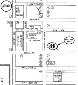
After checking into the Hilton Suites in Phoenix, my girlfriend and I immediately asked for a map of area restaurants, since neither of us had eaten all day. Hilton offered this apparently detailed map of the area.
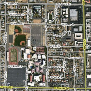
We decided to head to the Arizona Center for lunch and an early movie. Someone completely unfamiliar with the city might estimate that to be about a one-block walk. Fortunately, I’d glanced at Google Maps when planning the trip and knew the major streets were all several blocks apart. Let’s approximate my sketchy memory with this non-interactive Google Map of a nearby area.
Even in the desert heat, that would be a tolerable walk. We set out, leaving our bags, and unfortunately also leaving the map.
Unsure of exactly where we were headed, but knowing it to be south, we walked merrily on for many blocks before growing unsure of ourselves. We passed nobody on foot and began to worry we’d already passed the shopping center, perhaps a few blocks to the east.
Turning in that direction, we ran into our first passerby, whom we immediately asked for directions. “Well, I’m a tourist,” he said in a faint New Zealand accent. Then, after a beat, “but because I’m a tourist, I have a map.”
We’d now walked all the way to McDowell Avenue, and our fellow tourist’s map confirmed that the Arizona Center should be just three blocks east. Already starving and now dehydrated in the middle of the Arizona desert, when we found no obvious sign of the Center at 3rd street, we gave up and walked wearily back to the hotel.
The total journey, counting some weaving between Central Ave and 3rd Street, was about five kilometers.
After numerous glasses of iced tea and a much-needed meal, plus some time to sit motionless on our couch and recuperate, we renewed the idea of watching a movie. But this time we’d take the train, and we’d take the map.
The journey to McDowell on our second try took only minutes, and the walk to 3rd Street even less time. We could see now that the Center should be only a short distance south on Filmore street. We walked. And walked. And walked.
Growing again dehydrated and again exhausted, and now frustrated at having a useless map, we passed intersection after intersection. We passed over the whole of Interstate 10. We passed one apartment complex after the next. By the time we encountered someone else to ask for help, she confirmed the Center would be “straight ahead” and (as people always add when giving directions) that we “can’t miss it.”
We didn’t miss it, but in all we ended up walking another two kilometers from where we got off the train. We’d walked all the way to downtown Phoenix, passing six train stops, in sweltering desert heat, carrying now ater, and for most of the trip carrying no map. Tellingly, we passed almost nobody on foot.
Surely no intelligent person would deliberately walk seven kilometers in the Arizona desert (even in the comparatively cool May weather), yet the very occasion of our visit was to celebrate my girlfriend’s new Master’s degree. Two adults with graduate degrees should not end up in such a situation.
Of course, we’re entirely at fault for not bringing water, but we place the blame for everything else on shoddy map-making. Although we would not normally have expected to walk anywhere in Phoenix, this map recommends “Alexi’s Grill,” which is ostensibly a “short 1/2 mile walk,” and which appears on the map to be the same distance as the Arizona Center.
The map does disclaim itself “not to scale,” but that’s rather an understatement, and removes none of the real blame.


